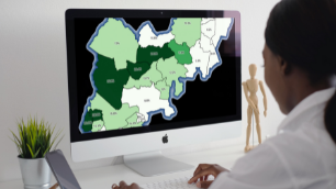
 A tree canopy survey provides an estimate of the ground area covered by tree canopy and can also include other vegetation associated with the urban forest. It calculates the percentage canopy cover of an area as a simple measure of the extent of the urban forest and the magnitude of services it provides.
Tree canopy surveys are scalable and can be carried out at local park or site level through to neigbourhood, ward, district, county or national levels. Assessment of tree canopy can also vary in its level of sophistication, ranging from a relatively basic i-Tree canopy study through to advanced GIS spatial analytics using remote sensing.
The purpose of a tree canopy survey is to provide baseline information about the extent of tree cover present in a given area. It also identifies the geographical location of trees within that area, highlighting any regions of high or low canopy cover. The survey allows comparisons to be made with other geographical areas where canopy surveys have also been carried out, and can show how one particular area is faring when compared with others.
Importantly, it provides a starting point for more effective management of the urban forest. With a growing focus on the importance of trees and the need for extensive planting, the tree canopy survey provides the first evidence base necessary for prioritising future tree planting and other management plans. It also provides a baseline for future canopy goals and targets to be set. So often, canopy growth goals and targets are put into the public domain without any evidence-based understanding of what the tree canopy actually is at the time, and whether aspirational canopy goals are achievable.
It is possible to sub-divide a geographical area, if a local authority is subdivided into political wards. This enables comparisons to be made and areas to be prioritised for planting and other actions.
The tree canopy survey provides an aerial overview, but it is important to realise that while useful, it is only the first step in a more articulate and strategic approach to urban forest management. The survey will not provide detailed information about species diversity, age, size, class or distribution, neither will it provide a detailed analysis of ecosystem services and other benefits delivered, or create an asset value for the trees. It will also only give an indication of areas with high or low canopy cover, but will not provide detailed information as to where new planting is possible or strategically important.
In conclusion, tree canopy surveys are valuable and introduce the concept of evidence-based strategic management of the urban forest. They provide a starting point from which other, more detailed and focused studies might be considered. In relation to long-term strategic management of the urban forest, tree canopy surveys are a good place to begin the journey.
If you would like to identify how much canopy cover you have and where you should target new tree planting, the first step is to measure urban forest canopy and set canopy goals. Treeconomics can assist you with a basic i-Tree canopy survey, or provide an advanced report with GIS spatial analytics, if desired.


